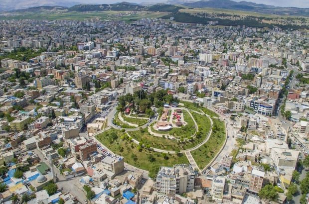
Adiyaman is located in the Middle Firat part of the Southeastern Anatolia Region. Adiyaman is home to Nemrut, the legacy of the Commagene Kingdom and one of the world’s most magnificent ancient cities. Nemrut Mountain, which has been on the UNESCO World Heritage List since 1987, is one of the greatest values of our country. Today, Adıyaman has important industrial foundations and important tourism potential. Thanks to the new investments in many parts of the city, the city has been developing at the last years.
Check out the most comprehensive Adiyaman city guide now. You will find the answers of many questions like “Places to see in Adiyaman” or “How to get to Adiyaman ?” in this guide.
City Name
Region
Population
Population Density
Population Growth Rate
Surface Area
Number of Districts
Postal Code
Area Code
GDP (Per Capita)
Adiyaman
Southeast Anatolia
626,465
82 / km2
0,31%
7,644 km2
9
02xxx
416
7,554 ₺
When we look at the districts of Adiyaman, we can say Kahta is the most developed district with more than 125.000 population. The vegetation of Adiyaman is generally steppe and steppe depending on its climate. The forest areas are weak, but the green areas are slightly more than the Southeastern Anatolia Region. Oak and pine forests are dense. Turkey’s Ataturk Dam is the largest artificial reservoir in terms of surface area, it remains largely within the borders of Adiyaman. Atatürk Dam, built on the Euphrates River, is one of the largest dams in the world in terms of filling volume.
The districts of Adiyaman are Kahta, Besni, Gölbaşı, Gerger, Sincik, Çelikhan, Tut ve Samsat. You will find detailed information for all districts of Adiyaman in this guide.
Short History of Adiyaman
Some drawings belonging to the Paleolithic Period discovered in the Palanlı Cave in Adiyaman show that these lands are one of the oldest settlements in the world. These mountain goat figures, which still remain prominent, are estimated to be 42 thousand years old. In other studies carried out in the region, traces of Paleolithic, Neolithic and Chalcolithic Periods were found.
With the Turkish invasions that started in the region after 1114, the region changed hands between states such as Anatolian Seljuks, Mamluks, Dulkadiroğulları, and finally became part of the Ottoman lands in 1516 with Yavuz Sultan Selim’s Iran expedition. During the Ottoman period, Adıyaman was first attached to the Maraş Beylerbeyliği and then to Malatya as an accident. which is a district of Malatya, Adiyaman until 1954, after that date has taken place in the Republic of Turkey as a separate province.
Accommodation in Adiyaman will be important if you are not resident in this city. Thanks to the increasing tourism potential of Nemrut Mountain National Park, new hotel investments started to made in different parts of the city. But, under today’s conditions, there are a few hotels to stay in Adiyaman.
If you are looking for real estate for sale in Adiyaman or real estate for rent in Adiyaman, you are on the right page. As of the end of July 2020 in Adiyaman, the prices of houses for sale increased by 16.81% in the last year. Average for sale residential property size is 160 square meters. Considering the annual averages, the districts that gained the most value in Adiyaman for housing as of the end of July 2020 were Kahta, Merkez, Gölbaşı and Besni, in descending order
Do you want to get detailed information about hospitals in Adiyaman ? In Adiyaman, there are 8 state hospitals, 1 training and research hospital and 2 private hospitals. Almost all districts have hospitals in different regions of the city.
Road Transportation
Adiyaman can be reached by road from five routes, namely Şanlıurfa, Malatya, Kahramanmaraş and Diyarbakır. Adiyaman’s Gölbaşı, Malatya Kahramanmaraş – Gaziantep highway transportation is provided through Gölbaşı.
Air Transportation
Adiyaman Airport is approximately 22 km away from the city center. It is possible to reach the city by Turkish Airlines on certain days of the week with direct flights from Istanbul and Ankara to Adiyaman. There are private passenger services running between the airport and the city center. You can also rent a car at Adıyaman Airport or use a taxi.
Railway Transportation
The train station in Adiyaman is approximately 70 km from the city center. It is located in the district of Gölbaşı, located at a distance. Euphrates Express, which makes regular daily voyages between Adana and Elazig, also passes through the Gölbaşı district of Adıyaman.
You will find the answers of the “Best places to visit in Adiyaman” or “Top 10 things to do and see in Adiyaman” questions in this guide. With no doubt, Nemrut Mountain is the symbol of Adiyaman and attracts the interest of many foreign tourists. Nemrut Mountain is located in the Taurus mountain range in the Kahta district of Adıyaman. Nemrut, which has been on the UNESCO World Heritage list since 1987, was taken under protection as Nemrut Mountain National Park in 1988. Haydaran Stone Tombs, it is where the rock tombs are located. It is 17 km from Adiyaman. It is located within the borders of Taşgedik Village to the north. The relief depicts the handshake of the Sun God Hellias and King Antiochos, made in a rectangular niche on the bedrock. St. Paul Syriac Church was built in the 18th century. It is in Adiyaman Central Mara District. It is understood from the 1905 inscription that the Church is a very old building. St. It is an Assyrian church called Pavlov.
There are only one state university located in Adiyaman named as Adiyaman University.


